


An Introduction to Spatial Data Analysis
Remote Sensing and GIS with Open Source Software
- An introduction to spatial data analysis using Quantum GIS (QGIS) and R
- Readers will learn to process and analyse spatial data, and to visualise and interpret the results
- Examples using real datasets and downloadable resources
- Open source rules again in spatial data analysis: a great trip into spatial data handling, spatial models and back!
—Duccio Rocchini, University of Bologna
- ecology
- GIS
- QGIS
- remote sensing
Related Books
Description
This is a book about how ecologists can integrate remote sensing and GIS in their research. It will allow readers to get started with the application of remote sensing and to understand its potential and limitations. Using practical examples, the book covers all necessary steps from planning field campaigns to deriving ecologically relevant information through remote sensing and modelling of species distributions.
An Introduction to Spatial Data Analysis introduces spatial data handling using the open source software Quantum GIS (QGIS). In addition, readers will be guided through their first steps in the R programming language. The authors explain the fundamentals of spatial data handling and analysis, empowering the reader to turn data acquired in the field into actual spatial data. Readers will learn to process and analyse spatial data of different types and interpret the data and results. After finishing this book, readers will be able to address questions such as “What is the distance to the border of the protected area?”, “Which points are located close to a road?”, “Which fraction of land cover types exist in my study area?” using different software and techniques.
This book is for novice spatial data users and does not assume any prior knowledge of spatial data itself or practical experience working with such data sets. Readers will likely include student and professional ecologists, geographers and any environmental scientists or practitioners who need to collect, visualize and analyse spatial data.
The software used is the widely applied open source scientific programs QGIS and R. All scripts and data sets used in the book will be provided online at book.ecosens.org.
This book covers specific methods including:
- what to consider before collecting in situ data
- how to work with spatial data collected in situ
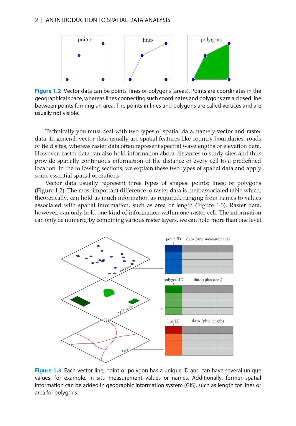
- the difference between raster and vector data
- how to acquire further vector and raster data
- how to create relevant environmental information
- how to combine and analyse in situ and remote sensing data
- how to create useful maps for field work and presentations
- how to use QGIS and R for spatial analysis
- how to develop analysis scripts
DOI: https://doi.org/10.53061/HCED6492
Reviews
- This book provides a much-needed, hands-on exposure to spatial data analysis using open-source QGIS and R software, taking novice analysts all the way from data acquisition to mapping, data analysis and the creation of new spatial information. Written by three leading experts in the field, this book provides an accessible, highly readable and comprehensive introduction to the topic.
—Harini Nagendra, Professor of Sustainability, Azim Premji University - Open source rules again in spatial data analysis: a great trip into spatial data handling, spatial models and back!
—Duccio Rocchini, University of Bologna - This book bridges the gap for ecological practitioners, enabling ecologists without a remote sensing background to visualise and analyse geospatial data.
—Inge Jonckheere, Teamleader Remote Sensing of the National Forest Monitoring Team, FAO - This book offers the clearest explanations of basic R concepts I’ve come across, such as the difference between data classes. ... I will be recommending this new volume to all my post-graduate students to help with study design and execution and would happily recommend it to my conservation practitioner colleagues too.
—Helen M. De Klerk, Stellenbosch University
About the Author
Martin Wegmann works on remote sensing for biodiversity and conservation applications at the Department of Remote Sensing, University of Würzburg. He also teaches remote sensing within the applied Earth Observation EAGLE M.Sc. program and the AniMove.org science school. He has more than 15 years of experience in working with spatial data for ecological applications using Open Source software.
Jakob Schwalb-Willmann is a scientist at the University of Würzburg with an academic background in Earth observation and spatial data science. His research focuses on the machine-learning-driven analysis and exploitation of integrated movement tracking and remote sensing data for geoanalytical applications. He has extensive experience in using and developing Open Source software tools for advanced image and spatial data anaylsis.
Stefan Dech is director of the German Remote Sensing Data Center (DFD) since 1998, and current spokesman of the Earth Observation Center (EOC) at the German Aerospace Center (DLR). Since 2001 he has held the Chair for Remote Sensing at the Institute of Geography and Geology of the University of Würzburg.
Bibliographic Information
 222 pages
 - 208 colour figures
- 2 tables
- BISAC SCI020000, SCI043000, NAT010000
- BIC PSAF, GPH, UNC