


Remote Sensing and GIS for Ecologists
Using Open Source Software
- Explains how to apply remote sensing and GIS to ecological research projects
- Practical examples cover each step, from planning through to remote sensing and modelling
- Based on open source software: Quantum GIS (QGIS) and R
- Remote Sensing and GIS for Ecologists could become an essential undergraduate-level textbook, but it is also a guide to practising ecologists who want to broaden their toolkit.
—Conservation Biology
- ecology
- GIS
- QGIS
- remote sensing
Related Books
Description
This is a book about how ecologists can integrate remote sensing and GIS in their daily work. It will allow ecologists to get started with the application of remote sensing and to understand its potential and limitations. Using practical examples, the book covers all necessary steps from planning field campaigns to deriving ecologically relevant information through remote sensing and modelling of species distributions.
All practical examples in this book rely on OpenSource software and freely available data sets. Quantum GIS (QGIS) is introduced for basic GIS data handling, and in-depth spatial analytics and statistics are conducted with the software packages R and GRASS.
Readers will learn how to apply remote sensing within ecological research projects, how to approach spatial data sampling and how to interpret remote sensing derived products. The authors discuss a wide range of statistical analyses with regard to satellite data as well as specialised topics such as time-series analysis. Extended scripts on how to create professional looking maps and graphics are also provided.
This book is a valuable resource for students and scientists in the fields of conservation and ecology interested in learning how to get started in applying remote sensing in ecological research and conservation planning.
Readership
Postgraduate, ecologistTable of Contents
Introduction
1 Spatial Data and Software
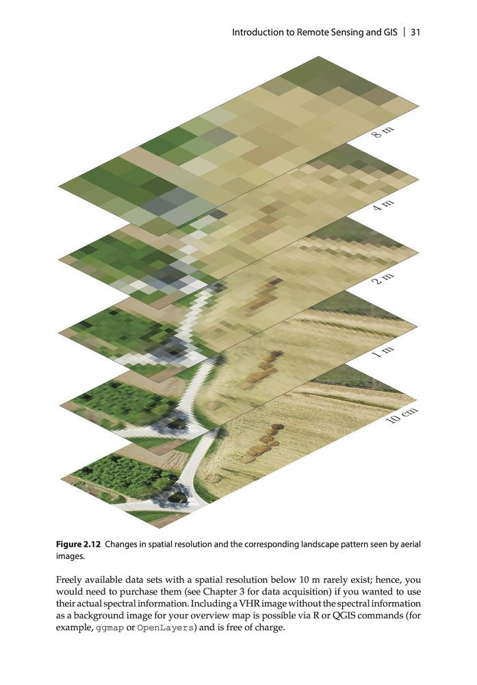
2 Introduction to Remote Sensing and GIS
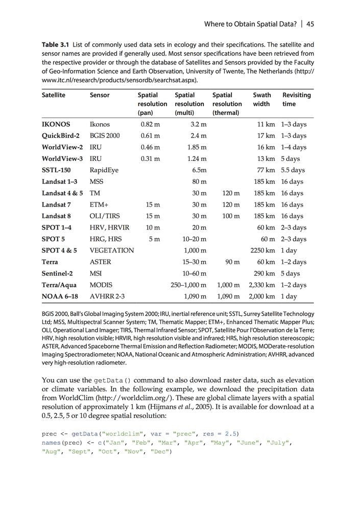
3 Where to Obtain Spatial Data?
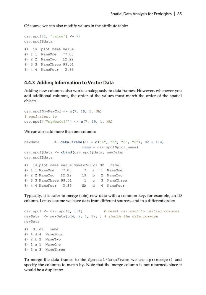
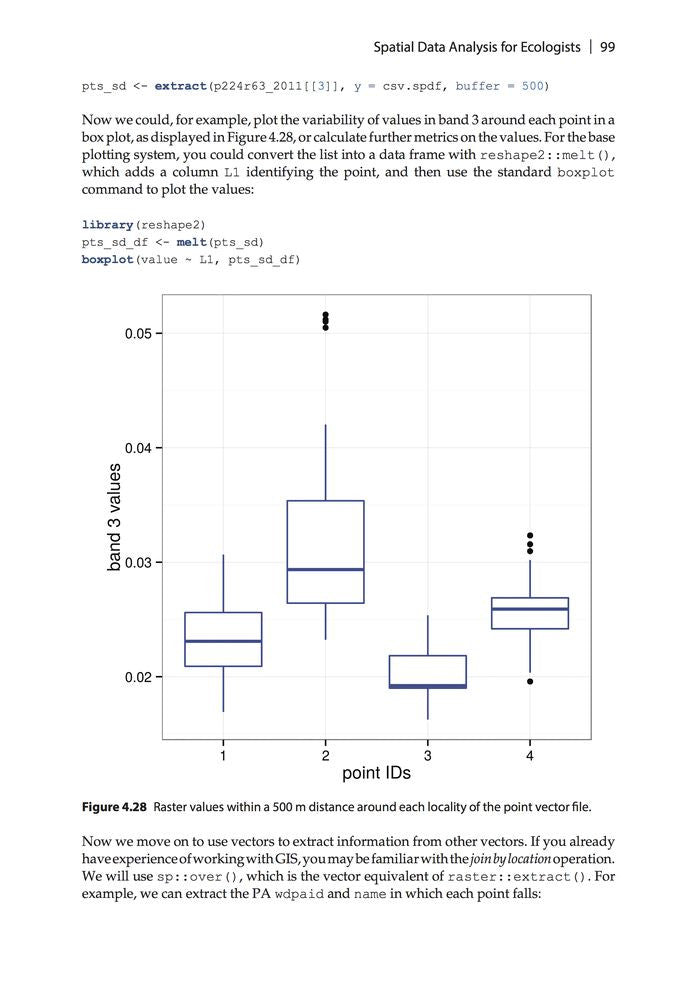
4 Spatial Data Analysis for Ecologists: First Steps
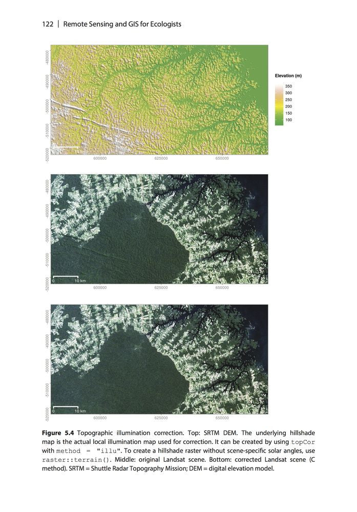
5 Pre-Processing Remote Sensing Data
6 Field Data for Remote Sensing Data Analysis
7 From Spectral to Ecological Information
8 Land Cover or Image Classification Approaches
9 Land Cover Change or Change Detection
10 Continuous Land Cover Information
11 Time Series Analysis
12 Spatial Land Cover Pattern Analysis
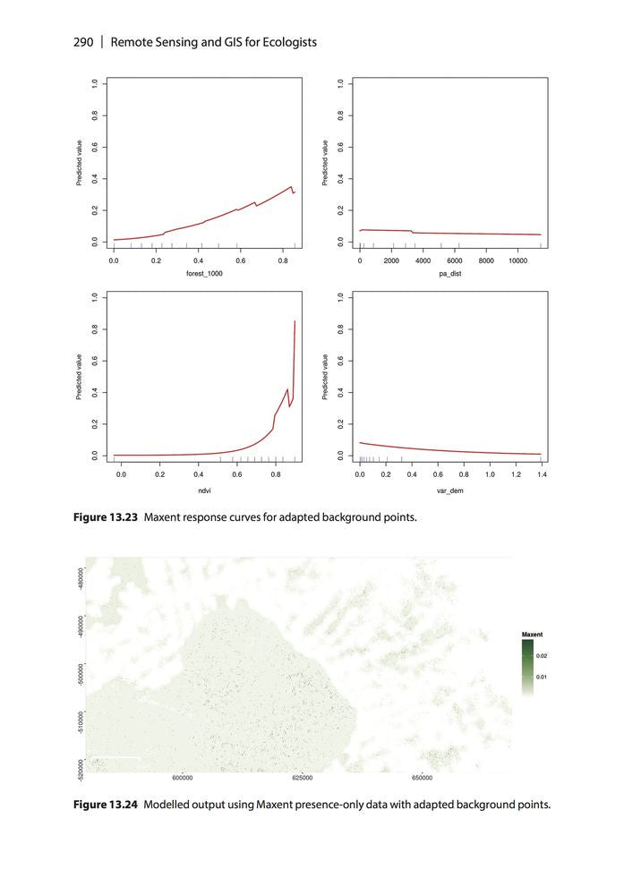
13 Modelling Species Distributions
14 Introduction to the added value of Animal Movement Analysis and Remote Sensing
Outlook and Acknowledgements
Index
Reviews
- Satellite remote sensing and GIS were once the preserves of a small number of well-financed groups, but the field has been democratised by open-source software. QGIS and R are covered by this textbook aimed at a practitioners who want to know how to obtain, process and analyse remotely sensed data. It provides excellent guidance on designing studies and recognising both the potential and limitations of remotely sensed data. Later chapters cover common ecological applications, including distribution modelling and land cover pattern analysis. The book is printed in high quality with numerous colour figures. It would make an excellent companion to a workshop. —Markus Eichhorn, Frontiers of Biogeography
- Many tips and tricks are taught in the exercise proposed. They are useful to understand how the software work and how to be efficient while working with them. This is important especially when working with a large amount of raster in R or simply on a wide area of interest, such as for time series or land cover patterns analysis, which could require an amount of RAM memory or even disk space, exceeding the ones available. The methodologies explained help to save computational resources, disk space and increase efficiency in terms of time. —Carlo Giupponi, Environmental Modelling and Software
- Importantly, this book enables the reader to learn a high-level concept and become familiar with the overall language used in the discipline, and then zoom in to the nuts and bolts of how to actually execute an analysis. Consequently, the book will be a valuable resource to ecological researchers, particularly because of the focus on open source software. —Allison Leidner, Universities Space Research Association/NASA Earth Science Division
- From how to begin with spatial data sampling, all the way through to the final creation of publishable maps and graphics, the book is an invaluable one-stop resource for ecologists, who are now increasingly utilising the power of spatial datasets for research, conservation practice and policy. —Harini Nagendra, Professor of Sustainability, Azim Premji University, Bangalore
- We recommend this book not only as an interesting and informative guide to remote sensing concepts, but also as a vehicle to quickly delve into hands-on processing and analysis of remote sensing data to answer many questions relevant to landscape ecologists. —Danica Schaffer-Smith and Jennifer J. Swenson, Landscape Ecology
About the Author
Martin Wegmann works on remote sensing data analysis for biodiversity and conservation application at the University of Würzburg. He is an assistant professor at the Global Change Ecology Msc program and founding member of the AniMove ‘animal movement and remote sensing for conservation’ school. He has more than 10 years of experience in working with spatial data for ecological applications using Open Source software.
Benjamin Leutner is a research assistant at the department of remote sensing at the University of Würzburg. He has extensive experience in geo-spatial analysis of remote sensing data using Open Source software. His research focus is on the application of hyperspectral and LiDAR data to species distribution modelling in support of biodiversity research and conservation.
Stefan Dech is Director of the German Remote Sensing Data Center (DFD) and current spokesman of the Earth Observation Center (EOC) at the German Aerospace Center (DLR). Since 2001 he has held the Chair for Remote Sensing at the Institute of Geography and Geology of the University of Würzburg. His research focuses on satellite remote sensing applications for terrestrial ecosystem research in the context of global change and sustainable land use.
Bibliographic Information
 352 pages
 - 220 colour figures
- 4 tables
- BISAC SCI020000, SCI043000, NAT010000
- BIC PSAF, GPH, UNC